 Image via Wikipedia
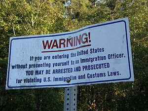
Maps, just like history, are inherently biased and are outdated the moment they are printed. We live in a dynamic world, with people with varying perspectives, and therefore a map does not convey an objective truth -- even if it might represent a widespread consensus. The existence of international boundaries and its highly arbitrary and political nature is an epitome of this phenomenon. We have the earth and its natural phenomena. We then have a map of the world, neatly divided into various coloured zones.
 |
| Look at the ditch on the right. It is a border. (0 Avenue, Surrey, B.C., just a few metres east of the Smugglers' Inn, Blaine, Wash.) |
 |
| The yellow concrete marks the end of Canada, while the USA welcomes neighbourhood walkers into the park with the sign "scoop your doggie poop." (On Peace Park Drive, Surrey, B.C., looking towards Peace Arch State Park, Blaine, Wash.) |
On the ground level, such borders can defy the reality and may even be
really silly, especially in case of the U.S. and Canada.
 Image via Wikipedia


0 comments:
Post a Comment